 1lookup
Data and validation APIs
From $4.00
per 1,000 address lookups; $9.90 on Starter

Census geography data
Prepaid credits from $10 for 500 records ($0.02 a record), falling to $1,200 for 1,000,000 records ($0.0012 a record)
tamu.edu
University geocoder with prepaid credits vs one flat answer per address matched
Texas A&M GeoServices costs less per record and covers census years from 1990, and 1Lookup returns the tract and its districts as one flat $0.010 lookup.
Looking for a Texas A&M GeoServices alternative? This page sets Texas A&M GeoServices pricing beside 1Lookup, with every Texas A&M GeoServices figure taken from its own published pages, checked October 2026.
- 7-day free trial on every plan
- No contract and no minimum volume
2
Credits per address matched
about $0.01 on Starter
0
Credits when not matched
no match, no charge
Up to 4
Other matches listed with the first
one charge for the whole lookup
2M
Rows in one CSV file
one address per row
At a glance
Here is where 1Lookup wins against Texas A&M GeoServices, and where Texas A&M GeoServices still wins.
Both turn a US address into the census tract it sits in. Texas A&M GeoServices is a university geocoder: registered users get 2,500 credits a month free, a free partner program refills 2,500 credits at a time in return for a public link, and prepaid credits fall to $0.0012 a record. With its census option it reports the block, block group, tract, county, metro area and place codes for 1990, 2000, 2010 and 2020. 1Lookup returns the current tract, block group, block, county, state, congressional district, metro area, place and school district together in one flat object, and an address the Census Bureau cannot locate costs nothing.
1lookupWhere 1Lookup wins- The congressional district, metro area, place and school district come back named beside the tract in one flat object, where Texas A&M's output field list gives codes and has no congressional or school district
- One API key and one balance: no free-credit refills, no partner link on your site, no separate prepaid purchase
- An address the Census Bureau cannot locate, a malformed entry and a lookup that could not be answered cost nothing, and a CSV with an address column of up to 2M rows returns one row per address
- The same key and balance also pay for phone, email and IP validation, and credits roll over for 3 months
What it costs
From $4.00
per 1,000 address lookups; $9.90 on Starter
Where Texas A&M GeoServices wins- Cheaper per record in volume: the prepaid table prints $0.02 a record at 500 records ($10) and $0.015 at 1,000 ($15), then $0.005 at 5,000 ($25), $0.0035 at 10,000 ($35) and $0.0012 at 1,000,000 ($1,200), and registered users get 2,500 credits a month free.
- Census years from 1990 to 2020: the API accepts census=true with censusYears of 1990, 2000, 2010, 2020 or allAvailable, and returns for each year the census block, block group, tract, county FIPS, CBSA FIPS, MCD FIPS, metropolitan division, MSA, place and state FIPS.
- It reports a census tract certainty code and name for the tract assignment for each census year, in the NAACCR standard.
- Terms are described as liberal on its pricing page: you can integrate the services into commercial, non-profit, web or mobile applications and store the data once you get it back.
- Interactive, batch, API, desktop client and Esri toolbox access, and a service level agreement and dedicated servers for heavy users.
What it costs
Prepaid credits from $10 for 500 records ($0.02 a record), falling to $1,200 for 1,000,000 records ($0.0012 a record)
Short answer
Texas A&M GeoServices is a geocoding service from Texas A&M University. With its census option the API returns census codes for the years you choose, from 1990 to 2020, and its output field list has no congressional district or school district. 1Lookup's Census Tract Lookup returns the tract, districts, metro area and school district as one object for 2 credits, about $0.010 on Starter, charged only when the address is matched.
What replaces what
Here is which 1Lookup product matches each Texas A&M GeoServices job.
Texas A&M spends one credit per transaction and returns census codes for the years you choose. This is the current geography for an address as one flat answer, charged only when the address is matched.
Side by side
Both products are measured on the same criteria, using Texas A&M GeoServices's own published numbers.
| Criteria | 1lookup | |
|---|---|---|
| Contact-data coverage | EmailPhoneIP | EmailPhoneIP |
| Pricing model | Monthly plans with universal credits; core phone, email and IP lookups cost 1 credit, enrichment and intelligence products cost more | Credits, one per transaction. Every registered user gets 2,500 credits a month free. A free partner program (attribution to the site required) lets you add 2,500 credits as often as you like, and prepaid credits run from $0.02 each for 500 records down to $0.0012 each for 1,000,000. Monthly plans, service level agreements and dedicated servers need custom setup. |
| Starting price | $99/mo for 20,000 credits. At 2 credits each (Census Tract Lookup API), that is $9.90 per 1,000 address lookups on Starter, down to $4.00 on Enterprise. | Prepaid credits from $10 for 500 records ($0.02 a record), falling to $1,200 for 1,000,000 records ($0.0012 a record). |
| Free option | Free single lookups via the online tools at 1lookup.io/tools, no account required | 2,500 credits a month for every registered user. Partners can add 2,500 credits as often as they like, free, in exchange for a public link or citation. |
| Free trial | 7-day free trial on every plan: $5 of credits on Starter, $20 on Growth, Professional, and Enterprise, with no payment today | None published |
| Do credits expire? | Unused monthly credits roll over for 3 months; separately purchased credits last 1 year | Not published |
At volume
This is what Texas A&M GeoServices charges at each volume it publishes.
| Volume | Price | Per 1,000 |
|---|---|---|
 1Lookup, every plan | $99 to $1,999 a month | $2.00 to $4.95 |
| 2,500 records a month (registered user) | $0 | - |
| 10,000 records (prepaid) | $35 | $3.50 |
| 100,000 records (prepaid) | $175 | $1.75 |
| 1,000,000 records (prepaid) | $1,200 | $1.20 |
Texas A&M GeoServices figures verified October 2026 against geoservices.tamu.edu.
How you buy
This is how you buy from 1Lookup and from Texas A&M GeoServices.
1lookupHow it is sold
Monthly plans with universal credits; core phone, email and IP lookups cost 1 credit, enrichment and intelligence products cost more
What it starts at
$99/mo for 20,000 credits
How you try it
7-day free trial on every plan: $5 of credits on Starter, $20 on Growth, Professional, and Enterprise, with no payment today
How it is sold
Credits, one per transaction
What it starts at
Prepaid credits from $10 for 500 records ($0.02 a record), falling to $1,200 for 1,000,000 records ($0.0012 a record)
How you try it
2,500 credits a month for every registered user
A real result
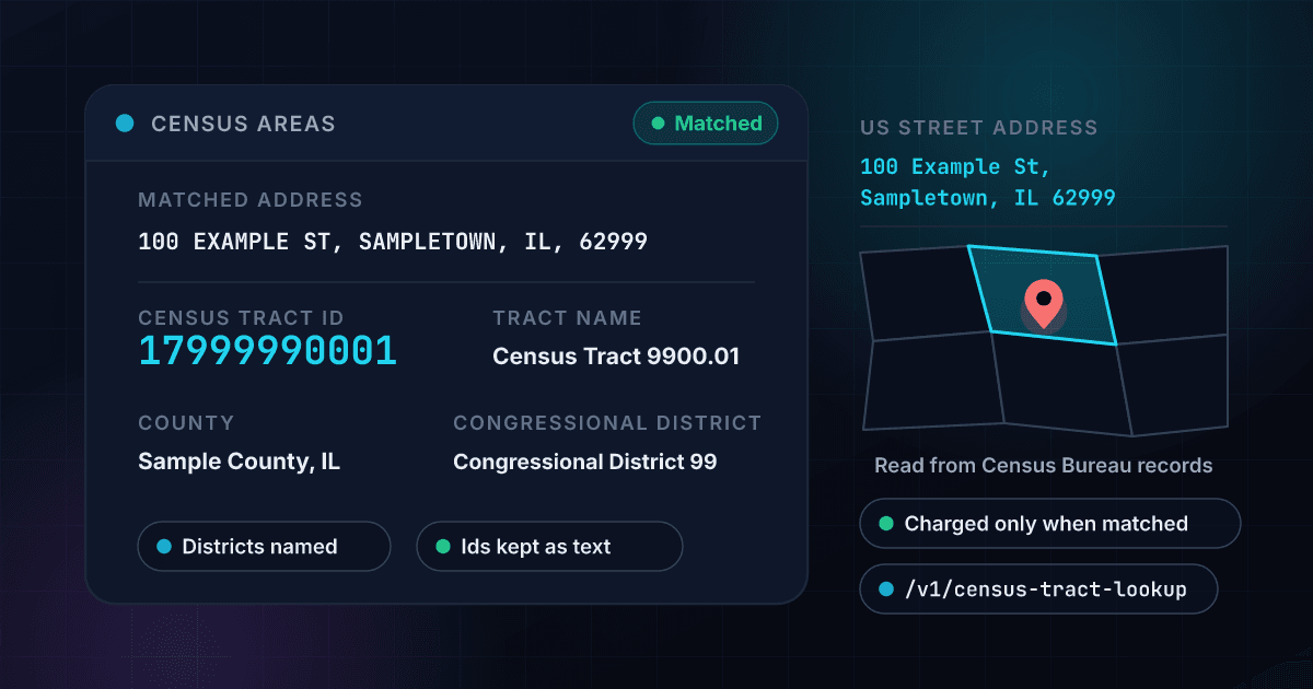
This is what one 1Lookup result looks like.
Send a US street address
POST the address as one line, or as a street, city, state and ZIP. It needs a street number and a street name. An email address, a web link or an address with no street number is refused with a clear error and costs nothing.
We ask the Census Bureau where it sits
The Census Bureau places the address on its own map and names every boundary around it. We keep the ids as text, put the names beside them and add the benchmark and vintage that answered.
Get the areas, flat and structured
Tract, county, district, metro area, place and school district arrive in one JSON payload. An address matched bills 2 credits, and an address the Census Bureau cannot locate bills nothing.
One call returns the census areas for an address
- Matched address
- 100 EXAMPLE ST, SAMPLETOWN, IL, 62999
- Census tract ID
- 17999990001
- Tract name
- Census Tract 9900.01
- Block group ID
- 179999900011
- County
- Sample County (17999)
- State
- Illinois (IL)
- Congressional district
- Congressional District 99
- Metro area
- Sampletown, IL Metro Area
- Place
- Sampletown city
200 OK, 2 creditsShowHide
{
  "classification": {
    "found": true,
    "matched_address": "100 EXAMPLE ST, SAMPLETOWN, IL, 62999",
    "tract_geoid": "17999990001",
    "tract_name": "Census Tract 9900.01",
    "block_group_geoid": "179999900011",
    "county_name": "Sample County",
    "county_fips": "17999",
    "state_abbreviation": "IL",
    "congressional_district": "Congressional District 99",
    "metro_area": "Sampletown, IL Metro Area",
    "place": "Sampletown city",
    "school_district": "Sampletown Community Unit School District 99",
    "match_count": 1
  },
  "recommendations": { "primary_action": "APPROVE" },
  "metadata": { "credits_used": 2 }
}Try the Free Census Tract Lookup by Address, one of 1Lookup's free tools.
Run one lookup in your browser and see the result before you decide.
The evidence
Here is the evidence behind every number on this page.
Here are Texas A&M GeoServices and 1Lookup side by side on the terms you check before you sign.
The terms that decide what a year actually costs, rather than what the first month does. “Not listed” means we could not verify it on either product’s published pages, not that the answer is nothing.
| Term | 1Lookup | Texas A&M GeoServices |
|---|---|---|
| Minimum commitment | None. Monthly plans with no contract and no minimum volume; cancel any time | Not listed |
| Going over your quota | Not listed | A positive credit balance is needed to use the services; each use of a service is one transaction and deducts one credit. |
| API access | Included on every plan and during the free trial; there is no tier that unlocks it | Needs an account and an API key from the account profile page; the REST API returns json, csv, tsv or xml. |
| Rate limit | 200 requests per 10 seconds for each API key on standard lookups and 1,000 requests a minute for each key on number type, HLR and MNP, and each account can make up to 1,000 requests a minute in total across all its keys; higher limits are available on request | Free use is throttled to 2,500 records a month and partner use to batches of 2,500, per the Usage Costs page. |
| Support | Starter: Email Support; Growth: Priority Email & Chat Support; Professional: Chat + Live Meeting; Enterprise: Dedicated CSM | A contact form; service level agreements are arranged through it. |
1Lookup
Texas A&M GeoServices

Texas A&M GeoServices pricing and product facts verified against geoservices.tamu.edu as of October 2026. Prices change, so confirm on the vendor’s site. 1Lookup numbers come from the live rate card.
Who it is for
Pick 1Lookup or stay with Texas A&M GeoServices depending on the job in front of you.
1lookupChoose 1Lookup if
you want district, metro and school-district names with the tract in one JSON object from one API key and a balance that also pays for phone, email and IP checks.
 Texas A&M GeoServices
Consider Texas A&M GeoServices instead if
you need census years from 1990 to 2020 or a tract certainty code, or you geocode in large volumes: Texas A&M's prepaid credits cost as little as $0.0012 a record, and registered users get 2,500 credits a month free.
Questions
People ask these questions before they switch from Texas A&M GeoServices.
What is Texas A&M GeoServices used for?
Geocoding US addresses, one at a time on the web, in batch files, through a REST API, a .NET API, a desktop client and an Esri toolbox. Its API takes census=true and a list of census years, and the output field list gives, for each of 1990, 2000, 2010 and 2020, the census block, block group, tract, county FIPS, CBSA, minor civil division, metropolitan division, MSA, place and state codes, with a tract certainty code in the NAACCR standard.
How does Texas A&M GeoServices pricing work?
Every registered user gets 2,500 credits a month free, and each use of a service is one transaction and one credit. A free partner program lets you add 2,500 credits as often as you like if you link to the service where the public can see it. Prepaid credits are $10 for 500 records ($0.02 each), $35 for 10,000, $175 for 100,000 and $1,200 for 1,000,000 ($0.0012 each). Monthly plans and service level agreements need custom setup, and the refund policy says payments are not refunded. Its fact sheet page prints 250 free credits a month where the other pages print 2,500. Checked October 2026.
How much does 1Lookup charge for the same lookup?
2 credits per address matched, free when the address is not matched. On the Starter plan ($99 a month for 20,000 credits) a lookup is about $0.010, which covers 10,000 addresses a month and is $9.90 per 1,000. At the Enterprise end of the rate card it is about $0.004. Texas A&M GeoServices is the cheaper bill from 5,000 records up: its first 2,500 records a month are free and its prepaid table prints $35 for 10,000 records, against $99 for a Starter month. At 500 and 1,000 prepaid records its price per record is higher than 1Lookup's Starter rate.
What does Texas A&M GeoServices return, and what does 1Lookup add?
Texas A&M returns codes: for each census year, the block, block group, tract, county, CBSA, minor civil division, metropolitan division, MSA, place and state, and the API page's output field list has no congressional district, state legislative district or school district. 1Lookup returns the current tract id and name, the block group and block ids, the county and state with their codes, the congressional district, metro area, place and school district by name, the coordinates and how many possible matches there were, in one flat object.
Where does Texas A&M GeoServices beat 1Lookup?
On price at volume, history and fine print. Registered users get 2,500 credits a month free and prepaid records cost as little as $0.0012 each. It returns census geography for 1990, 2000, 2010 and 2020 side by side with a tract certainty code, offers service level agreements and dedicated servers, and its pricing page says you can store the data once you get it back. 1Lookup returns the current geography only, with districts and names, and has no certainty code.
What do I need to start with each?
Texas A&M needs an account, and its API needs the API key from your account profile page. Its partner program also needs a link or citation that the public can see: links or citations visible only to internal operations do not qualify. 1Lookup needs an API key and a credit balance, with a 7-day free trial, and nothing is linked from your site.
Can I check a list of addresses at once?
Yes on both. Texas A&M has a batch processing tool where the Address, City, State and Zip fields must be present in the file even if they are blank, and it recommends smaller batches to finish faster. 1Lookup takes a CSV with an address column of up to 2M rows and returns one row per address with the tract, county, district, metro area, place and school district, and a row that is not matched is a free row.
What is the best Texas A&M GeoServices alternative?
If you geocode in volume, need census geography for past years or a tract certainty code, or want the lowest price per record, Texas A&M GeoServices is the better fit. If you want a US address turned into the current tract and its districts in one flat answer, with a free miss and one balance that also pays for phone, email and IP checks, 1Lookup's Census Tract Lookup bills 2 credits only when the address is matched.
Is Texas A&M GeoServices worth it in 2026?
If you want free credits each month, a price that falls to $0.0012 a record and the census years from 1990 to 2020, yes, and its terms let you store what you get back. If you want the congressional district and school district with the tract, or one price per address without counting free and prepaid credits, compare the per-lookup price of 1Lookup.
1lookupLook up a US address and see its census tract and districts
Try 1Lookup free for 7 days and compare it with Texas A&M GeoServices on your own work.
2 credits an address matched, about $0.010 on Starter, on the same balance as phone, email and IP checks. Start with the 7-day free trial.
Keep going
Keep researching Texas A&M GeoServices with the matching 1Lookup pages.
Use 1Lookup
Compare another provider
- 1Lookup vs Census Geocoder$0: the documentation prints no price, charge or key requirement
- 1Lookup vs GeocodioFree up to 2,500 lookups a day, then $1 per 1,000 lookups on pay-as-you-go (US, Canada and Mexico only)
- 1Lookup vs Google Geocoding API10,000 free billable events a month, then $5.00 per 1,000 requests up to 100,000 a month



More on Texas A&M GeoServices